Understanding GPS Signal Acquisition and Signal Strength
Overview:
The Global Positioning System,
beginning in the 1980s, completing deployment in 1995.
applications.
service - the United States will continue to provide and improve GPS, the European Union will complete deployment
of their system, GALILEO and Russia will complete deployment of their system GLONASS.
The GPS is a constellation of 32 fully operational satellites orbiting the earth in 6 different orbital planes, with 5 to 6
satellites per orbit.
one of the 24 needs to come offline for maintenance issues.
kilometers (about 12 miles). Each orbit takes about 12 hours,
it’
satellites in each plane are designed to ensure that there are a minimum of 4 satellites in view of an
earth at any time.
position data. Receivers positioned in higher latitudes will typically
for the entire GPS network is located in Colorado.
GPS Signal Strength:
GPS signal strength can be affected by many conditions.
movement, and the orbital position of the satellites.
receiver is attempting to get a full GPS lock (typically means the reciever is locked onto a minimum of 4 satellites for
accurate location data).
• When considering the weather
clouds can be a negative when it comes to GPS signal locking.
process.
• Environmental considerations include whether the receiver is in a mountainous or flat area, urban or rural area,
under a tree canopy
canyons. It can be hard to receive a satellite signal when not much sky is visible.
buildings, sometimes referred to as urban canyons,
areas, where the receiver may be under tree-lined roads or trails,
effect on the GPS signal.
with lots of open sky
• The global satellite network itself can also affect the GPS signal.
of 24 satellites in 6 different orbits around the earth.
hole” may temporarily exist,
at that particular point in time. In this case,
movement to “c
• Receiver movement can have an affect on the initial GPS signal lock.
unit stationary while the unit is tr
the locking process, the process may take more time to complete.
process, distances to each satellite are being calculated.
change and thus a recalculation.
• The GPS signal is a radio frequency (RF) signal.
reception. Indoors,
type of material the roof or walls are constructed from. Outdoors,
can affect electro-magnetic radiation (EMR), like solar flares from the Sun.
tracked and predicted, by various organizations.
toward the earth, your GPS signal will be affected.
T:
As mentioned above, the GPS network was designed prior to the 1980s.
receiver on the ground is only 50 bits per second. In perfect weather conditions,
with the first satellite, it takes a minimum of 30 seconds to receive the initial information,
A receiver will need to lock on a minimum of 4 satellites to get an initial good position location. In order to find other
satellites the receiver will reference a copy of a data file, containing position data of all other satellites in the system.
file is commonly referred to as the almanac file. Each satellite is in constant communication with the other satellites in
the system. Each satellite continually gathers up-to-date position data of the other satellites.
the bulk of the almanac file. Receivers typically keep their copy of the almanac file updated without notice to the user
However
not powering it up for a long time. If this is the case,
approximately 12.5 minutes under good sky conditions (the almanac file is approxima
downloading at 50 bits/sec). Once the first satellite is locked,
up-to-date or a new one is downloaded, the receiver begins to look for and lock other satellites.
process is accelerated at this point because finding additional satellites is much quicker once the receiver kno
to look for them via position info from the now up-to-date almanac data.
Cell phones acquire a GPS lock faster then other receivers. Most of the newer phones use what is called
Assisted GPS technology
acquire a GPS signal lock quickly using assistance from other technologies.
triangulation, the high speed data transmission link between the phone and the tower
fixed position, is always locked onto and monitoring the GPS satellite constellation,
Leveraging these technologies, the cell phone can acquire a GPS signal lock quickly compared with other receivers
communicating directly with the satellites at 50 bits per second.
Dashboard to Menus
Back to Previous Screen
Menus to Dashboard
Find Sensors
Interval/Ride Mode toggle
Sleep
Ride Menu Quick Display
Metric Rotation
Quick Backlight
Shifting, T
Manual Zero
PowerBeam Calibration
Active Bike
Ride Partner (P
Joule GPS User Guide page 66
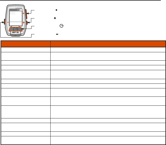
Appendix E: BUTTON COMBINA
WATTS
283 160
21 96
1:06:45
HR
MPH CAD
214 894
AV WATTS MX WATTS
RIDE TIME KJ
9:34
A
71º
780
INT
[ENTER] button
[MINUS] button
[PLUS] button
[INTERVAL] button
Button Combination,
Press and hold the ENTER button for 3 seconds
When in Menus, c
field click INTERV
Press and hold the ENTER button for 3 seconds, or c
Press and hold the PLUS and MINUS buttons at simultaneously for 2 seconds.
Press and hold the INTERVAL button for 2 seconds to toggle between metric data related to
the whole ride and metric data related to the current interval/la
Press and hold the PLUS and INTERVAL buttons at simultaneously for 3 seconds.
Press and hold the MINUS button for 2 seconds
Press and hold the PLUS button for 2 seconds, continue hold while highlighted metric rotates.
Release when desired is in main window.
Click the MINUS and INTERVAL buttons simultaneously to turn backlight
until next sleep; additional clicks scroll through brightness settings.
When paired to an i400 series indoor cycle,
increase/decrease the T
highlighted on W
A link to the Manual Zero screen of the active bike is on the Sensors menu.
A link to the PowerBeam Calibration screen appears on the Sensors menu when the active
bike definition includes an RU sensor
The Active bike is pre-selected when entering the Sensors menu.
Choice appears on the Ride menu when a route with pacing data is active. Selecting this choice
forces the Ride Partner to be